SAN FRANCISCO — Authorities urged motorists to avoid California’s Highway 1 along the central coast after a section of the scenic route collapsed during an Easter weekend storm, forcing closures and stranding motorists near Big Sur, authorities said.
The collapse occurred amid heavy rain Saturday afternoon near Rocky Creek Bridge about 17 miles south of Monterey, sending chunks of asphalt tumbling into the ocean from the southbound side of the two-lane road.
The highway was closed in both directions in the mountainous area of California’s central coast as engineers assessed the damage, said the state Department of Transportation, or Caltrans.
“We are working on a plan to get motorists evacuated from the area,” the California Highway Patrol said Saturday.
The Rocky Creek closure on California Highway 1 on Sunday in Monterey County following heavy rain in the area. Caltrans District 5 via AP
Around noon on Sunday, crews had determined that travel in the northbound lane was safe, and authorities began periodically escorting motorists around the damaged section. About 300 cars were waiting to travel northbound when officials led the first convoy through the area, the San Francisco Chronicle reported.
Some stranded motorists had slept in their cars overnight while others were sheltered at the nearby Big Sur Lodge, the newspaper said.
Caltrans spokesperson Kevin Drabinski said periodic convoys would continue over the coming days as crews shore up the highway, which had other closures because of rocks and debris in lanes. He urged people to avoid the area.
The famous route has seen frequent closures because of collapses, mud flows and rockslides during severe weather.
The slow-moving storm dumped heavy rain at lower elevations and more than a foot of snow at Sierra Nevada ski resorts around Lake Tahoe.
Ryan Kittell, a National Weather Service meteorologist, said the system is typical for March but was not an atmospheric river like many of the other storms that have pounded the state in recent winters.
The storm exited the San Francisco Bay Area on Friday and “just marched right down the California coast,” bringing most of the rainfall to the Los Angeles area, Kittell said.
The storm then parked itself over Southern California, where it was expected to stay until Sunday night or into Monday. Showers and possible thunderstorms, with the potential for lightning and damaging winds, were still possible for parts of Santa Barbara, Ventura and L.A. counties.
A powerful storm brought heavy winds, snow and rain to the central United States on Monday, making travel hazardous and “nearly impossible” in some areas, with extreme weather on both coasts set to last into Tuesday.
The National Weather Service said early Monday that the Northern and Central Plains into the Upper Midwest would be affected, with sleet and freezing rain reaching as far as the Mississippi Valley.
Minnesota could see snowfall of 6 to 12 inches an hour, bringing travel chaos to the Twin Cities.
A 51-year-old woman died Sunday in Burnsville, 15 miles south of Minneapolis, after her vehicle ran off the road and struck a tree, police said.
Minnesota State Patrol named her as Elizabeth Evans of Lakeville and said she was driving north on Interstate 35E approaching County Road 42 at the time of the accident, NBC News affiliate station KARE 11 reported.
The state patrol said there had been at least 328 crashes reported as of 9:30 p.m. on Sunday, involving 13 injuries. More than 200 vehicles spun out or slid off roads, while 10 semi-trailers jack-knifed.
Some 20 million people across the continental United States, from the West Coast to Michigan’s Upper Peninsula, were subject to weather warnings Sunday.
California was rocked by a spring storm on Sunday, with hailstones the size of quarters and winds as strong as 60 mph, the NWS said. Lake Tahoe received about a foot of snow, potentially a boost for ski resorts — although several were forced to close ski lifts on Saturday after recording wind gusts measuring more than 90 mph.
Dramatic video captured the moment the L.A. Fire Department rescued a 35-year-old woman from the Los Angeles River, fast-moving and swollen from the storm waters. She was picked out of the rapids by a firefighter lowered by a rescue helicopter. She was taken to a hospital with only minor injuries and hypothermia, the fire department said.
Hundreds of traffic accidents across the Northeast were reported to police overnight as icy conditions took hold.
Over the weekend a powerful weather system battered the tri-state area, with more than 2 feet of snow and downed power lines in some parts. Vermont saw as much as 30 inches of snow, the weather service said.
More than 100,000 customers were still without power in Maine, along with 22,000 in New Hampshire and 12,000 in New York, as of 6:30 a.m. ET Monday, according to PowerOutage.us, which tracks energy connections.
Central Maine Power, the state’s largest utility, said in a statement early Monday that it had returned power to half the 200,000 customers affected by the storm, after responding to some 775 emergency calls.
The planet was just slammed with what government officials dubbed a severe geomagnetic storm, the second-highest level of NOAA’s rating system. The event brought “a major disturbance in Earth’s magnetic field” that may have impacted infrastructure and made the northern lights visible farther than usual, officials said.
NOAA’s Space Weather Prediction Center issued a geomagnetic storm watch on Saturday, saying that a coronal mass ejection was detected and expected to hit the planet late that same day with impacts into Monday. Coronal mass ejections, or CMEs, are when a large cloud of plasma and magnetic field bursts from the sun’s corona.
This particular CME exploded alongside a solar flare on Friday, an event that occurs when electromagnetic radiation suddenly erupts from the sun. NOAA says these flares can last hours and the eruption “travels at the speed of light,” meaning it can impact Earth as soon as it is observed. An X-class flare, like what was observed with the CME, is the strongest type of flare, although this particular one was not the strongest on record. NOAA forecasters did say, however, that more X-class flares are possible through Wednesday.
“The public should not be concerned, but may wish to keep informed by visiting our webpage for any forecast changes and updates,” NOAA said on Saturday, saying a moderate geomagnetic storm was possible. By Sunday afternoon, however, the agency alerted of a “severe” storm that could potentially impact technology – and eventually extend the northern lights as far south as Alabama.
This is a video summary of the 22 March solar flares, coronal mass ejection (CME), and eventual CME arrival at Earth on 24 March – with resultant geomagnetic storms. The CME progression continues at this time. pic.twitter.com/u5FeeSMzGp
“The public should not anticipate adverse impacts and no action is necessary, but they should stay properly informed of storm progression by visiting our webpage,” NOAA said in its alert, adding that “normally mitigable” problems with voltage control was possible, as well as “frequent and longer periods of GPS degradation.”
“Infrastructure operators have been notified to take action to mitigate any possible impacts,” the agency said.
On Monday morning, NOAA said that the impacts of the CME “appear to be weakening,” but that solar wind speeds – which help carry the event – were still elevated. The warning of a “moderate” storm has since been extended. Moderate geomagnetic storms, classified as G2, can potentially impact high-latitude power systems, damage transformers and extend the northern lights to New York and Idaho. It can also potentially require flight ground control to issue corrective actions for orientation.
Li Cohen
Li Cohen is a social media producer and trending content writer for CBS News.
A high-impact winter storm is forecast to bring rain and snow to an area spanning from California through the northern Plains to Michigan’s Upper Peninsula.
About 14 million people are under winter weather alerts Sunday, including in Tahoe, California; Denver; Minneapolis; and Sioux Falls, South Dakota.
More than 12 inches of snow had already accumulated in Alta, Utah, as of Sunday morning, while 7.3 inches of snow had fallen in Flagstaff, Arizona.
Heavy snow will continue to develop over the central and northern Plains on Sunday afternoon, with blizzard conditions that will create hazardous travel conditions overnight, affecting parts of Colorado to Minnesota.A dangerous combination of 2 inches per hour of snowfall and 60 mph wind gusts is possible.
“Strong winds and heavy, wet snow on trees and power lines may damage trees and cause power outages,” the National Weather Service said in an update Sunday. “Wind gusts over 50 mph today may result in power outages, blowing dust with reduced visibility, difficult travel and property damage.”
Steady snow showers will persist through Monday, with snow clearing out and into Canada by Tuesday evening.The area from Nebraska to northern Wisconsin will likely seeabout 8 to 16 inches of snow, with some areas receiving up to 20 inches.
This same storm system will also spark heavy rain and severe weather concerns across the southern Plains and Southeast through the next two days.
On Sunday, the storm is forecast to target Kansas and Oklahoma, including Wichita and Dodge City. Storms this afternoon and overnight will be capable of producing very large hail,tornadoes and damaging wind gusts.
A car passes through snow on Clark Avenue after a spring snowstorm in Ames, Iowa, on Friday.Nirmalendu Majumdar / USA Today Network
By Monday, this risk will shift into east Texas and the lower Mississippi Valley, affecting 7 million in Louisiana, including New Orleans, Baton Rouge and Shreveport. Damaging wind gusts will be the primary concern with any storms that form Monday afternoon and evening, with a few tornadoes possible.
Localized flash flooding may also occur across the South including in Missouri, Arkansas, Mississippi and Alabama, where rainfall totals through Tuesday will range from 1 to 3 inches, and locally up to 4 inches.
Over the weekend, a powerful weather system affected the tri-state area with heavy rain and strong winds, as a fast-moving storm blanketed northern New England with snow.
Snowfall totals as of Saturday evening included 24.5 inches in Landgrove, Vermont, 20.5 inches in both Corinth, New York, and Claremont, New Hampshire, and 13.5 inches in Sweden, Maine, according to the National Weather Service.
On Sunday, weather in the tri-state area is expected to be breezy, with wind gusts of over 30 mph forecast, according to the National Weather Service field office in New York.
SEOUL, South Korea (AP) — Dozens of flights and ferry services were grounded in South Korea on Wednesday ahead of a tropical storm that has dumped rain on Japan’s southwestern islands for more than a week.
Khanun’s heavy rains and winds were expected to arrive in South Korea’s southern and eastern regions Wednesday afternoon, South Korea’s weather agency said. It is expected to reach the southern resort island of Jeju hours later and then make landfall near the mainland port of Tongyeong early Thursday.
The agency says Khanun could have a punishing impact as it will likely slice through the center of the country over several hours while packing winds blowing at 90 to 154 kph (56 to 97 mph) before moving to North Korea early Friday.
The Korean Meteorological Administration measured Khanun at typhoon strength with maximum winds of 126 kph (78 mph) as of 9 a.m. Wednesday, as it passed through waters 360 kilometers (223 miles) southeast of Jeju while moving northward at a speed of 12 kph (7.4 mph).
Japan measured Khanun as a severe tropical storm with sustained winds of 108 kph (67 mph) and higher gusts. Warnings for stormy conditions, potential flooding and other risks were issued for the southwestern part of Japan’s southern island of Kyushu and nearby areas.
As a stronger typhoon last week, Khanun lashed Okinawa and other Japanese islands, causing injuries and damage.
South Korean President Yoon Suk Yeol has called for officials to be aggressive with disaster prevention measures and evacuations while stressing the perils posed by the storm, which comes just weeks after the country’s central and southern regions were pounded by torrential rain that triggered flashfloods and landslides that killed at least 41 people.
The Korea Airport Corporation said at least 144 flights going in and out of Jeju were canceled as of 11 a.m. as Khanun approached. Ferry services connecting the island with mainland ports were also cancelled while authorities shut down at least 39 roads, 26 riverside parking lots and 613 hiking trails nationwide as part of broader preventive measures.
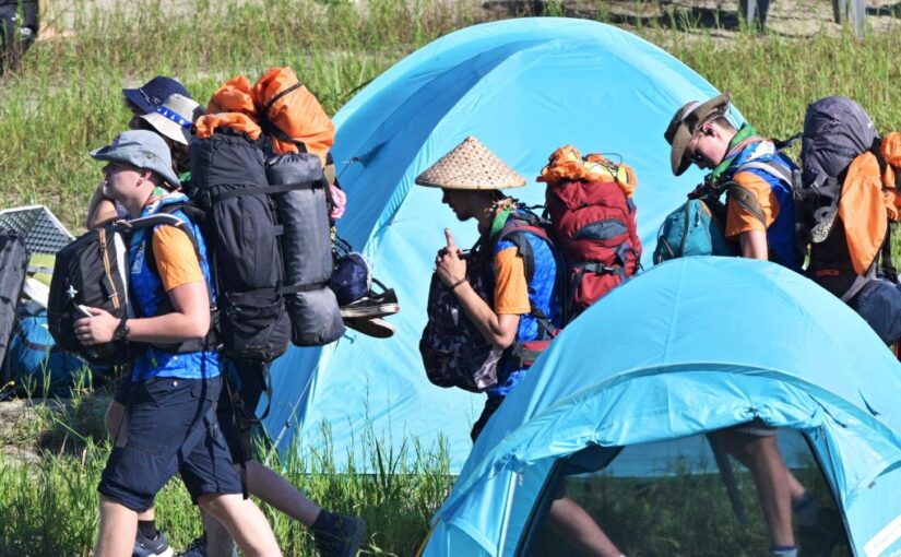
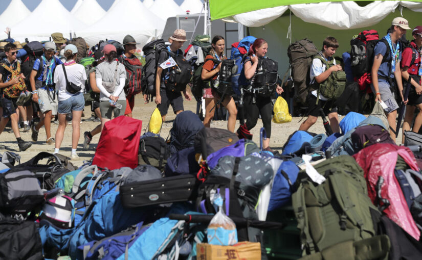
Khanun has forced South Korea to evacuate the World Scout Jamboree that had been taking place at a coastal campsite in the southwestern county of Buan. Officials on Tuesday mobilized more than 1,000 buses to transfer 37,000 global scouts to university dormitories, government and corporate training centers and hotels in the capital Seoul and nearby areas.
Eye Opener: Deadly storms hit eastern U.S. – CBS News
Watch CBS News
Deadly storms hit the eastern U.S., causing widespread damage and knocking out power for hundreds of thousands. Also, former President Donald Trump’s attorneys argue against restrictions on what he can say about his indictments. All that and all that matters in today’s Eye Opener.
Be the first to know
Get browser notifications for breaking news, live events, and exclusive reporting.
Critics have argued the push to host the Jamboree at Saemangeum was part of efforts to justify further investment in the site, where local officials continue to pursue plans for new highways, ports and an international airport. The airport was initially planned to be built for the Jamboree, but construction hasn’t started yet.
Before Tuesday’s pullout, government officials channeled national resources to keep the event going, adding medical staff, air-conditioned buses, military shade structures, and hundreds of workers to maintain bathrooms and showers, which some Scouts complained were filthy or unkempt.
Organizers said the campsite will not be used for any other events after the Scouts leave.
More than 270 police cars and four helicopters were deployed to escort the buses that began departing the site on 9 a.m., said Lee Sang-min, South Korea’s Minister of the Interior and Safety. The evacuation is expected to take six hours or more.
More than 13,500 scouts will be accommodated at 64 different venues in Gyeonggi province, South Korea’s largest province surrounding Seoul. About 3,100 scouts will stay in Seoul and another 3,200 will be sent to nearby Incheon. Nearly 9,000 scouts will be sent to 25 different venues in the North and South Chungcheong provinces in the country’s central region, Lee said.
“Local governments are checking the sanitation of the accommodation venues and restrooms and are preparing medical measures to ensure that the participants would be safe and comfortable after they arrive,” Lee said. “Police will patrol the accommodations, while officials from the Korea Food and Drug Administration will carefully check the quality, quantity and safety of meals.”
The announcement about the evacuations came after the World Organization of the Scout Movement said it called on South Korea to quickly move the Scouts from the storm’s path and provide necessary resources for participants until they return to their home countries.
“This is the first time in more than 100 years of World Scout Jamborees that we have had to face such compounded challenges,” said Ahmad Alhendawi, secretary general of the World Organization of the Scout Movement, who credited South Korea’s government of “mobilizing all available resources” into the relocation effort.
“It’s disappointing that these adverse weather conditions have forced us to shift our plans,” he said.
SEOUL, South Korea (AP) — Buses began moving tens of thousands of Scouts to inland venues Tuesday ahead of a tropical storm, bringing an effective end to a World Scout Jamboree that had already struggled with heat, hygiene and land use controversies.
Known for its insatiable desire to host international events, the South Korean government scrambled to keep the Jamboree going as thousands of British and American Scouts departed over the weekend because of an extreme heat wave that caused some attendees to be hospitalized.
It wasn’t until Monday afternoon that officials announced the decision to abandon the coastal campsite in the southwestern town of Buan, after forecasters raised alarms that Tropical Storm Khanun was heading toward the Korean Peninsula.
South Korean officials say the Jamboree will continue in the form of cultural events and activities, including a K-Pop concert in Seoul Friday.
Critics have argued the decision to host the Jamboree at a site known as Saemangeum was part of an effort to justify further investment in a controversial swath of reclaimed land.
More than 1,000 vehicles are being used to evacuate 37,000 Scouts from 156 countries, mostly teenagers. Most will be accommodated in Seoul and the surrounding area, where officials have secured university dormitories, government and corporate training centers, and hotels.
Tropical Storm Khanun has meandered around Japan’s southwestern islands for more than a week, dumping heavy rain, knocking out power and damaging homes.
Early Tuesday morning, the storm was centered 350 kilometers (217 miles) south of Kagoshima, a city on the southwestern tip of Japan’s main southern island of Kyushu. Khanun produced winds of 108 kph (67 mph) with gusts to 144 kph (89 mph) and was slowly moving north, the Japan Meteorological Agency reported.
South Korea’s weather agency, which measured the storm at typhoon strength of 126 kph (78 mph), expected it to gain strength slightly before making landfall Thursday morning. It’s expected to bring strong winds and heavy rains to South Korea from Wednesday to Friday.
South Korea’s safety ministry instructed local officials to prepare to shut down coastal areas, hiking trails, river parks, underpass tunnels and other places vulnerable to flooding.
The Jamboree began last Wednesday at the campsite in Saemangeum, a huge area reclaimed from sea by a 19-year project that was completed in 2010. It has remained largely barren site as local officials continue to pursue plans for highways, ports and an international airport. Once seen as major development project that would revamp a region that lacks modern industries, Saemanguem is now increasingly viewed as an ecological disaster that wiped out coastal wetlands and hurt fisheries production.
Concerns had been raised beforehand about having such large numbers of young people in a vast, treeless area lacking protection from heat. Hundreds of participants were treated for heat-related ailments after the Jamboree began, as South Korea grappled with one of its hottest summers in years.
Critics have argued the push to host the Jamboree at Saemangeum was part of efforts to justify further investment in the site, where local officials continue to pursue plans for new highways, ports and an international airport. The airport was initially planned to be built for the Jamboree, but construction hasn’t started yet.
Before Tuesday’s pullout, government officials channeled national resources to keep the event going, adding medical staff, air-conditioned buses, military shade structures, and hundreds of workers to maintain bathrooms and showers, which some Scouts complained were filthy or unkempt.
Organizers said the campsite will not be used for any other events after the Scouts leave.
More than 270 police cars and four helicopters were deployed to escort the buses that began departing the site on 9 a.m., said Lee Sang-min, South Korea’s Minister of the Interior and Safety. The evacuation is expected to take six hours or more.
More than 13,500 scouts will be accommodated at 64 different venues in Gyeonggi province, South Korea’s largest province surrounding Seoul. About 3,100 scouts will stay in Seoul and another 3,200 will be sent to nearby Incheon. Nearly 9,000 scouts will be sent to 25 different venues in the North and South Chungcheong provinces in the country’s central region, Lee said.
“Local governments are checking the sanitation of the accommodation venues and restrooms and are preparing medical measures to ensure that the participants would be safe and comfortable after they arrive,” Lee said. “Police will patrol the accommodations, while officials from the Korea Food and Drug Administration will carefully check the quality, quantity and safety of meals.”
The announcement about the evacuations came after the World Organization of the Scout Movement said it called on South Korea to quickly move the Scouts from the storm’s path and provide necessary resources for participants until they return to their home countries.
“This is the first time in more than 100 years of World Scout Jamborees that we have had to face such compounded challenges,” said Ahmad Alhendawi, secretary general of the World Organization of the Scout Movement, who credited South Korea’s government of “mobilizing all available resources” into the relocation effort.
“It’s disappointing that these adverse weather conditions have forced us to shift our plans,” he said.
Severe storms threaten nearly one-third of U.S. – CBS News
Watch CBS News
More than 6,000 flights were delayed and another 1,400 canceled Monday night as thunderstorms threaten more than 104 million Americans. The most severe storms are expected into Tuesday morning. CBS News correspondent Meg Oliver has more on the damage we’re already seeing.
Be the first to know
Get browser notifications for breaking news, live events, and exclusive reporting.
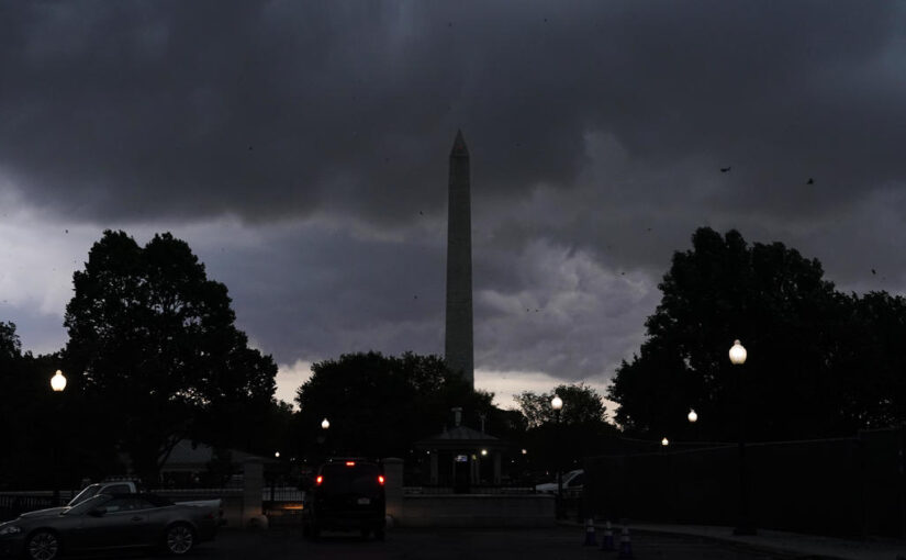
Tornado watches and warnings were posted along the East Coast on Monday as meteorologists warned millions of people to brace for severe thunderstorms, damaging winds and large hail.
The National Weather Service forecast “very active” weather on the East Coast from late afternoon into the evening, with severe weather, heavy rains and flash flooding possible from the Southeast to the Mid-Atlantic and up into parts of the Northeast.
Storm clouds the Washington Monument in Washington, D.C., on Monday, Aug. 7, 2023.
Jacquelyn Martin / AP
Strong winds downed trees in Maryland, where more than 96,000 customers lost power across the state, CBS Baltimore reported.
The greatest threat was expected across the southern and central Appalachians to the Mid-Atlantic region, according to the weather service. The storms knocked down trees and caused other damage in Tennessee earlier, and there were reports of golf-ball sized hail in West Virginia.
“Some perspective: This is the first moderate risk for severe weather in at least 10 years for much of our forecast area,” the NWS service out of the Baltimore-Washington area said on social media.
The National Weather Service forecast for the East Coast shows extreme weather.
National Weather Service
Federal employees in Washington, D.C., were told to go home early because of the extreme weather forecast, with federal offices set to close at 3 p.m., according to the U.S. Office of Personnel Management.
Heavy rains and flash floods are a concern for eastern New York into New England Monday evening into Tuesday. Ping pong ball-sized hail was possible in some areas.
With the threat of severe weather ongoing, there have been thousands of flight delays and cancellations, according to the flight-tracking website FlightAware.
The Federal Aviation Administration said it was re-routing flights around the storms as much as possible in the afternoon, but then issued ground stops for a number of major airports stretching from Atlanta and Charlotte up through Washington, D.C., Baltimore, Philadelphia and the New York City area.
Parts of the region have already dealt with extreme rain and flooding in recent weeks. Several people died in Pennsylvania during flash flooding last month. There was also deadly flooding in New York.
New York City’s Emergency Management department on Monday activated the city’s Flash Flood Plan in anticipation of the weather system.
Aliza Chasan
Aliza Chasan is a digital producer at 60 Minutes and CBS News.